Climbing, skiing, and mountaineering
Beyond geology research, climbing is my favorite way to explore Earth’s landscapes. For me, this includes everything from gym bouldering, to Yosemite big walls, to Alaskan ridge routes—and it often involves carrying skis on my back. Although this is primarily a academic research site, the two activities are often linked—climbing gets me to the rocks I want to look at.
This page is a work in progress, but its aim is to archive both memories and useful information pertaining to interesting routes, as well as research-related mountain expeditions. Please contact me for more information regarding any climbs or areas mentioned here.
Sections:
1) Cerro Mercedario, San Juan, Argentina, 2022
2) Archangel Ridge, Sultana, Central Alaska Range, 2021
3) Madison Traverse and Montana Backcountry, ~2020
4) Denali and West Ridge of Begguya, Central Alaska Range, 2019
5) Thank you (Yosemite Poster)
Cerro Mercedario, San Juan, Argentina – 2022
See Caden Howlett’s more in-depth account of our climb in a recent blog post on TravelingGeologist.
At 6,720 m (22,047 ft) ASL, Cerro Mercedario is the highest mountain in the Cordón de la Ramada and the 8th highest in the Andes. In 2022, Caden Howlett and I collected a thermochronology profile up the Inca Route on its northeast ridge. These samples allowed us to reconstruct the history of exhumation during construction of the High Andes, recently published in Tectonics.

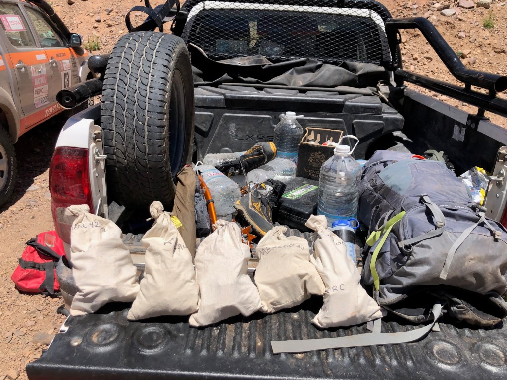
The mountain is accessed from Barreal, Argentina. As of the time of writing, the roads are maintained by Glencore-Pachón mining company and generally passable in a decent AWD vehicle. However, several portions seem to wash out with some regularity and may require a beefier truck. Laguna Blanca (~3,300 m) comprises the staging area, and an area with some permanent guide infrastructure called Guanaquitos (~3,600 m) serves as an advanced base camp. Three more camps lie at intervals along the northeastern ridge, as detailed in this route description.

We climbed the route over eight days, including one gear carry and two rest days to acclimate. We left from Pirca del Indio (5,175 m) for our summit push and skipped the final camp at La Hoyada (5,650 m). I think this is a good strategy—given the exposed position and thin atmosphere of the latter—although it requires ~1,700 m of climbing.

Archeologists believe that Incans first summited the peak around 500 years ago. Near our high camp, they have found evidence of a capacocha—a sacrificial ritual in the religion of the Incan Empire to honor their most important deities. I can see why they chose Mercedario’s slopes for this important ceremony—it’s strikingly beautiful.

A trip report by Caden is the subject of an upcoming TravelingGeologist article, so I won’t spoil the details here. But, it was a fantastic expedition and a great opportunity to climb in the name of science.
(Caden’s blog post is now up. See it here.)
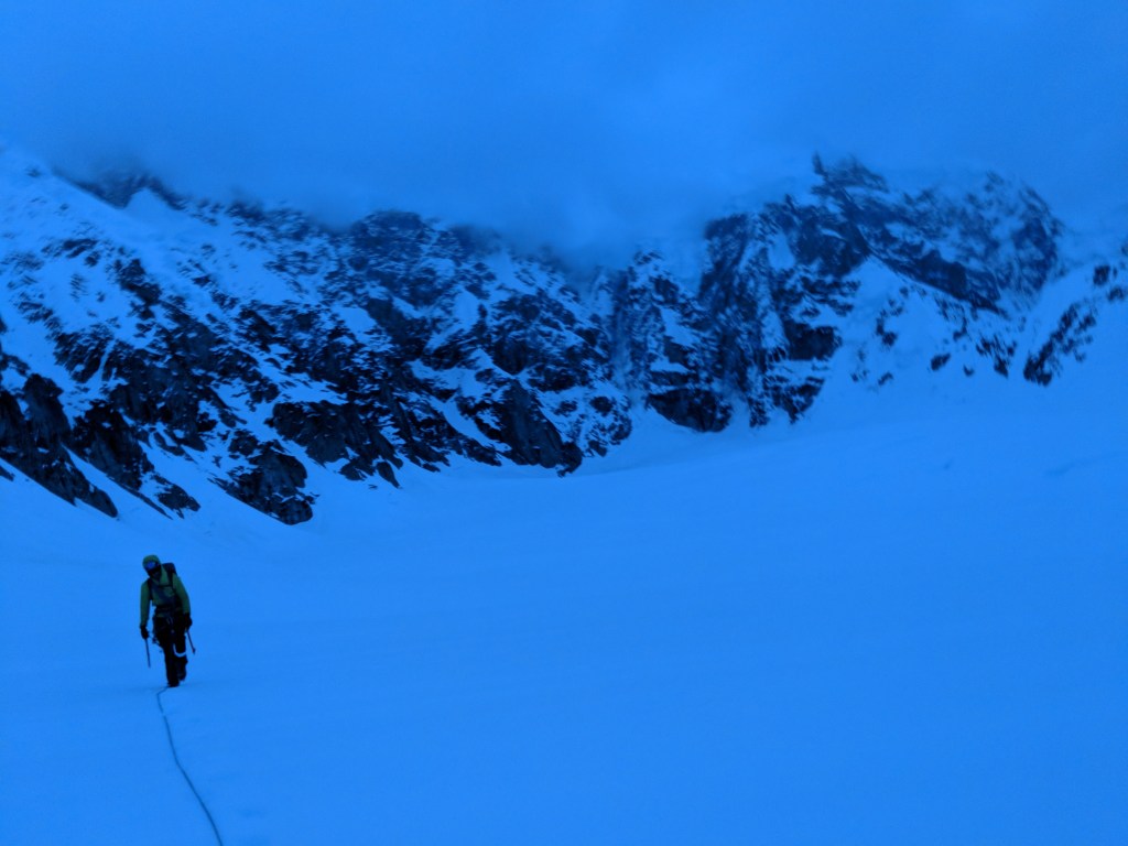
Archangel Ridge, Sultana, Central Alaska Range – 2021
In May 2021, Tucker Hoefler, Ryan Griffiths, and I completed what was (to our knowledge) the third ski descent of the Archangel Ridge of Sultana (AKA Mount Foraker; 5,304 m / 17,400 ft) in the Central Alaska Range.

The native Koyukon had two names for this mountain: Sultana meaning “the woman” and Menlale meaning “Denali’s wife”. Although it was unfortunately renamed after an 1800s Republican senator from Ohio, the former names are more fitting—Sultana is the second highest peak in the range and stands as a Denali’s formidable companion on the skyline above Talkeetna.
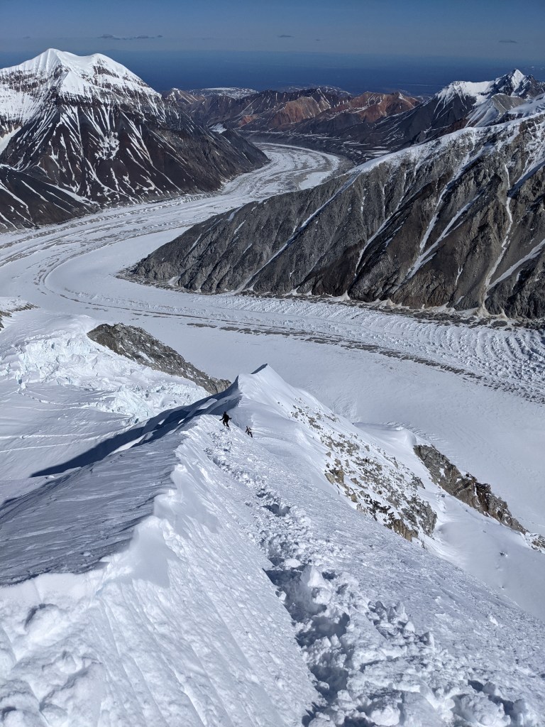
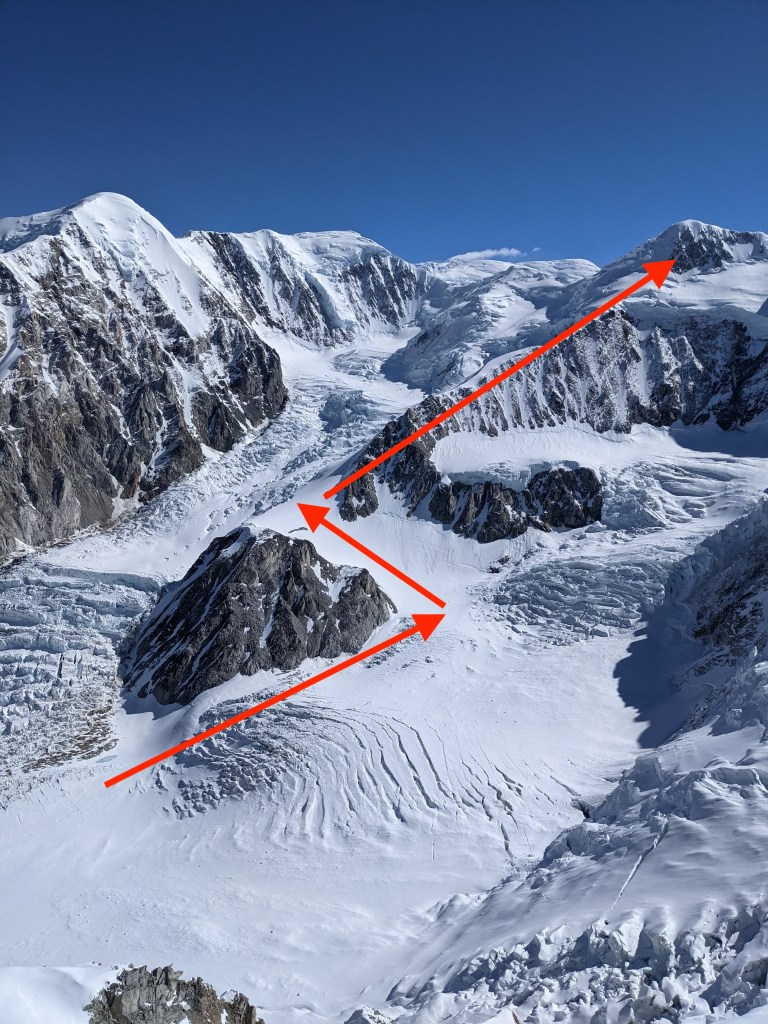
We flew on an Otter ski plane into the Kahiltna glacier— the basecamp for climbs of Denali’s West Buttress. After some warm-up skiing and gear caching missions, we decided to attempt our goal—the Archangel ridge of Sultana. First, we climbed the east face of Mount Crosson and slept near its summit. The following morning, we cached our bivy gear except for one Firstlight tent to save as much weight—and therefore energy—as possible. Over the next day, we crossed the Crosson–Sultana ridge and climbed the northeast ridge of the latter peak (known as Sultana Ridge). This was complex terrain requiring roped travel due to omnipresent crevasse hazard, but it went surprisingly smoothly with no falls.

We crossed paths with Jackson Marvell and Alan Rosseau just shy of the summit. They had climbed the Infinite Spur and were descending the northeast ridge (along with Matt Cornell, they would go on to win the Piolet d’Or for their ascent of Jannu’s north face in 2024; good job boys!). We paused briefly on the summit of Sultana in beautiful light but extreme wind and cold.

We then began our ski descent of Archangel ridge—a striking convexity comprising the only safe passage through the terrifying northwest face of Sultana. The upper portion of the route was scraped down to blue ice in places and very difficult skiing. Although we’d planned on reaching a warmer, lower elevation camp on the Foraker glacier, we were forced to bivy about half way down the ridge. This was a cold night—three grown men with no sleeping bags cuddled in a two-person tent.
We continued our descent the next morning, beginning with a harrowing ice-axe-in-hand section down the ‘knife edge ridge’. I’m glad we waited until daybreak. Thereafter, conditions improved. The nearly a vertical kilometer of powder gave way to more open slopes of corn snow. We reached the Foraker glacier and found liquid water in a ‘tropical’ melt pond! Altogether, we skied a continuous > 3,300 m (10,800 ft)—amounting to one of the longer ski descents possible on Earth (I think Mount Saint Elias holds this title). We did no rappels and used crampons very sparingly.

We then re-climbed a minor ridge leading to the Crosson-Sultana saddle and retraced our steps toward our cache near the summit of the former peak. During this process, a storm moved in early and we were enshrouded in a whiteout. Through the grace of deity or Darwin, Ryan stumbled across our gear cache before we ourselves stumbled into a crevasse.

There, we spent a very windy night without much sleep before deciding to decend despite the unrelenting storm conditions. With our electronic navigation equipment dying, I finally admitted that maybe wands are occasionally a good idea. Finding our way to the base of the clouds, the Kahiltna glacier opened up below and we skied glorious corn (okay, it was chunky refrozen chunder) back down to the relative safety of the Kahiltna.
Although our snow conditions were not the glorious pow that rewarded Noah Howell’s years of reconnaissance, this trip was very special to me because it completed my efforts to climb the Central Range’s ‘Big 3’ (Denali, Begguya, and Sultana), and it was just an incredible way to experience the mountains with friends.
The Madison traverse and backcountry skiing in Montana
In March 2020, Chris Kussmaul, Ryan Griffiths, and I skied from Earthquake Lake to Spanish Creek, along the crest of the Madison Range of Montana. Marika Feduschak accompanied us for the portion south of Sphinx Mountain, which comprises the Taylor-Hilgard traverse. We covered spectacular terrain—from glades to big couloirs (possibly including a poach of The Big Couloir…) and from Archean basement rock to Eocene ignimbrites.
The traverse took us about six days, and the world was a different place when we returned; COVID-19 had begun to spread in the US and isolation orders were going into effect. There was no way I would have rather entered over a year of relative solitude than a week crossing some of Montana’s finest landscapes with friends.
This traverse—along with hundreds of other backcountry skiing routes—is now recorded in Kussmaul’s book: Peaks and Couloirs of Southwest Montana. Beyond just a guide to local skiing, this book is a fantastic tribute to the mountains of the Treasure State—complete with high-quality aerial photos and a regional geology section that I authored.

Denali and Begguya,
Central Alaska Range – 2019
In May–June 2019, Matias Francis and I climbed the West Buttress of Denali (Mount McKinley) to acclimate for an attempt on the Cassin Ridge. The former ascent was successful, but the latter was aborted due to medical issues. We went on to climb the West Ridge of Begguya (Mount Hunter), which was one of the richest experiences I’ve had in the mountains. Some details, mainly on the West Ridge climb, are below.
West Buttress ascent and Seattle Ramp descent, Denali
Denali is beautiful, and our acclimation ascent went off without a hitch. We carried gear mainly on skis up to 14 Camp (major camp at 14,000′) and used them for acclimation ascents up to ~17,000′. I would recommend this approach over snow shoes for most. We summited in a push from 14 Camp—skipping the exposure and elevation of 17 Camp, as Caden and I would go on to do on Mercedario in 2022. Again, I find this tactic to be a good decision for most—nothing good happens sleeping above 17,000′ in Alaska.
I won’t provide a detailed description of our ascent here, since there are abundant and superb resources online for those preparing for a West Buttress climb.

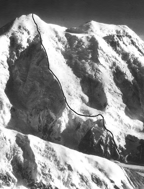
Having summited ‘The Great One’ and feeling well acclimated, I was excited to get over to the mountain’s South Face and away from the crowds. We descending the Seattle Ramp (AKA Seattle ’72 or Wickwire Ramp), which links Denali’s 14 Camp to the start of the Cassin Ridge. Although this approach has been the subject of some debate, we found it to be quite manageable—it certainly seemed simpler and safer than descending the West Rib or hiking up the Kahiltna’s northeast fork. However, it does require some tricky top-down route finding through crevassed terrain, and I recommend carefully studying a route photo like that here.

Despite our route-finding success, medical issues would soon stop us in our tracks. I developed a cough while ascending to the cut-off at ~16,000′, which continued to worsen into unmistakable High Altitude Pulmonary Edema (HAPE) by the time we reached the base of the Cassin. Climbing was now out of the question. We spent one night in the northeast fork as my condition deteriorated, and we realized we would have to descend as soon as possible.
Although most of our gear was back at 14 Camp, reascending the Seattle Ramp was out of the question. We were ultimately forced to bail out the northeast fork of the Kahiltna glacier. This arm of the glacier is known as the ‘Valley of Death’ for its exposure to towering seracs. We found ourselves in the unenviable position of traversing this ‘bowling alley’ in mid-day sun, when seracs are most likely to calve. Fortunately, Matias maintained composure and found our way through a maze of cravesses, delivering a barely lucid Chance to lower elevation. I rested at Ski Hill camp while Matias reascended to recover our cache. I ultimately recovered quickly and was able to assist him with the effort.

As a bit of a side note, this was my second experience with HAPE. Both instances occurred while I was seemingly well-acclimated. In this case, I’d been living above 14,000′ for over a week and had been above 20,000′ to Denali’s summit two days prior. Peter Hackett (high-altitude medical researcher, personal doctor for the Rolling Stones, Colorado yak rancher, my friend Tashi’s dad, and candidate for most interesting man in the world) has subsequently helped me figure out how to better prevent HAPE. I’ve since had good luck with prophylactic doses of Nifedipine and Acetazolamide (Diamox), which I credit with preventing issues during my ascents of Sultana and Mercedario. You can read the Wilderness Medical Society’s most recent guidelines for treatment and prevention of altitude illnesses here.
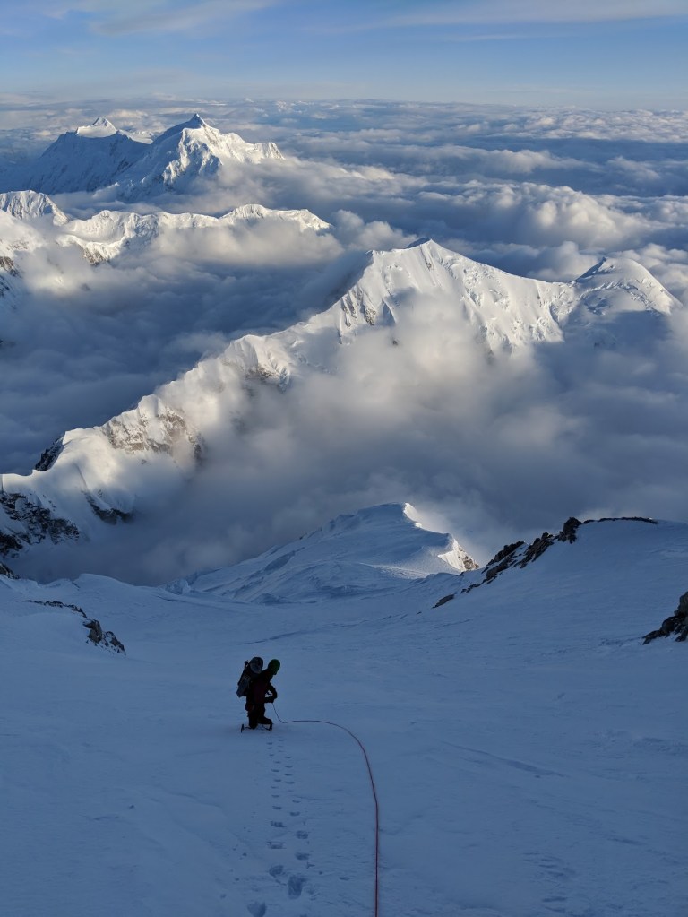
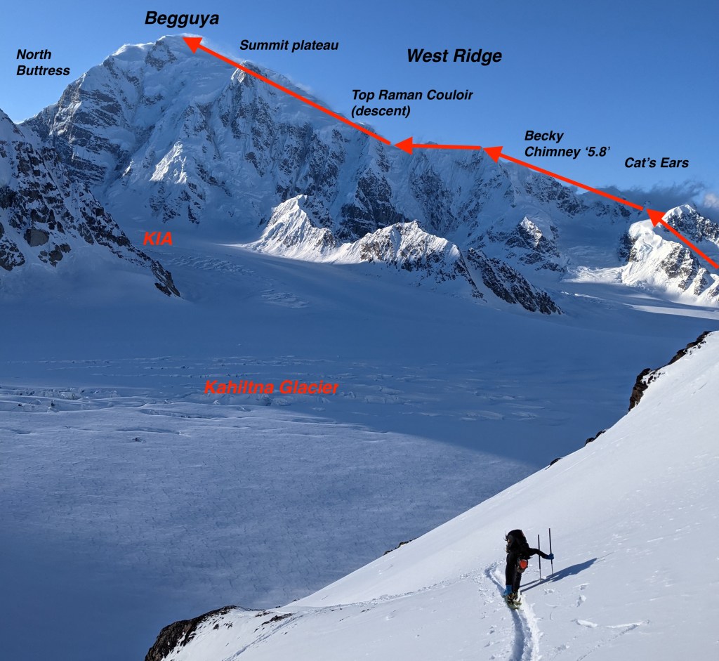
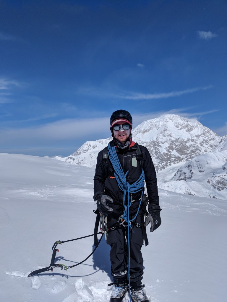
West Ridge of Begguya (Mount Hunter)
Fortunately, I recovered speedily at Ski Hill camp. Feeling healthy at elevation again, we decided to attempt Begguya (Mount Hunter) with our friends Ryan Griffiths and Chris Kussmaul, who had just skied Denali’s Messner couloir. At 14,573 ft (4,442 m), Begguya is significantly lower than it’s ‘mom and dad’ (Begguya means ‘Denali’s child’) and we felt confident in our acclimatization. Unlike Denali, however, Begguya has no ‘easy way’ up. We decided to climb the West Ridge—which carries a seemingly approachable grade of 5.8 YDS. We found this route to be very involved—certainly not the plastic 5.8 at our local gym.
What follows is an excerpt from Matias’s blog post on CascadeClimbers, describing our climb (with some additions and edits for clarity):

“””
We left at 6 pm the day before the weather window, skinning down to the base of the route at 6500’. The first section was snow and had some considerable overhead hazard. We were able to move quickly and make our way up to the Cat’s Ears, where we did two 60-meter rappels to the base of an ice face. We kept trucking along the beautiful ridgeline until we got to the rock steps. There, the ‘5.8’ Beckey Chimney proved to be more demanding than expected. A few more simul pitches (climbing roped together at the same time with intervening protection) of some easy mixed terrain brought us to a nice bivy (campsite) at around 4 am. We then slept until 10 am and continued on the ridge. Some more rambling ridge terrain moved slowly on, as we tunnelled through cornices and dealt with some deep snow. We finally got to the base of the “ice face”—which didn’t have any ice on it.
Just before hitting the saddle, Chance was downclimbing a snow face and he took a crevasse fall—fully overhead. After pulling him out, the four of us were a bit shaken. We still had lots of ridge to go and were unsure of the weather in the future. Ryan and Chris made the decision to bail back down from there, leaving Chance and I a bit more ‘out there’ than we were planning. (They were climbing in ski boots, and Ryan’s feet were in bad shape). We were sad to see those two go, but knew that we were going to be able to move a bit faster and focus more on the climbing. We continued moving up, passing another easy mixed pitch and an overhanging serac feature that required legit WI5 (approximately vertical) ice climbing, even for just a body length. We made it to the top of the famed Ramen Couloir and got caught in a whiteout. With no ability to see where we were going, we decided to bivy again. We split one mountain house (freeze dried meal) between us, beginning to strictly ration food.
We had planned on a single push effort. But, due to the weather, we decided to wait until the morning (to finish the ascent). After sending out (satellite) messages for weather info, we received confirmation that we would have climbable weather the following day. We slept. We woke to beautiful clear skies and the ability to see the route in front of us. A bit of new snow made trail breaking more difficult. But, after some chest-deep postholing, we arrived onto the summit plateau.

The plateau seemed safe and smooth, and we couldn’t see any cracks. We both got complacent, and Chance walked up on me while I was trying to route find. The new snow had blanketed a massive crevasse. I popped in and fell 25 feet, dropping my trekking pole and a picket. I was fortunate to be ok and was able to climb out. We learned from our mistakes and kept going toward the summit. The final 50° snow pitch turned out to be blue ice covered in 3 inches of snow. It made for slower progress than anticipated, but we were on the summit of Begguya after a short ridge traverse. We saw wonderful views of the South Face of Denali and many other parts of the range.
Now we just had to get down.
We descended back to the camp above the Ramen Couloir and finished our food, besides one single Gu. We made 5 or 6 V-thread rappels down the upper part of the couloir, after which we decided to unrope and start downclimbing. The conditions were great besides the final 1,000 feet, where it turned into 3-inch breakable crust to bottomless facets. We eventually made our way to the base of the Ramen somewhere around midnight (exiting onto a hanging glacier on the south side of Begguya). Out of food and physically wasted, we were unsure where the sneak-around was (safe route to get back to the Kahiltna glacier, bypassing a complicated icefall where the hanging glacier meets the main fork of the Kahiltna.). The Supertopo beta (route information) said to climb 700 feet up an “easy snow slope.” (We did so,) then blindly started rappelling into a couloir (that ended in a > 300 m overhang) and had to climb back out.
Chance and I are great friends, but in this instant, we were mad at each other and tempers were flaring. We took a pause at 2 am and brewed up (melted water), realizing being mad wasn’t going to solve any of our problems. We had a route description, but couldn’t pick the correct gully. Finally we chose one in which we could see the bottom, but not the middle. Our hand was forced by the fact that we couldn’t afford to spend much more time on the mountain (no food, no fuel, minimal water, and deteriorating weather). We left gear as we descended, using all of our slings—even my prusik cord. One nut anchors and chossy cam placements led us down to more steep snow. Similar to the conditions in the Ramen but worse; we made slow progress.
This was where I had started to hallucinate.
The snow was variable. The mini slide paths in the couloir proved firm enough to front point down, whereas the rest of the snow surface was slow and deep. The trick of the slide gullies was to get out of them when the barrage of rocks and ice funneled down the 5 foot deep paths. It was a risk, but I wanted to get off this thing so bad—the safety of the Kahiltna was right in front of us.
The whole ordeal from the bottom of the Ramen to the safety of the Kahiltna lasted around 10 hours. We then walked back to our skis at the base of the route. While skiing out the Kahiltna, a heavy cloud layer moved in and started dumping snow on us. We just really didn’t care. We were off and thankful to be alive.

With no food or fuel and very little water, we continued the journey back to the airstrip. Our phone GPSs had died and were “walking blind”. We walked into the wrong basin, mistaking it for the airstrip. I realized our mistake just short of an extremely crevassed area. We finally make it back to our camp at the airstrip and subsequently stuffed our faces with bacon and sausages and chocolate. By 5 pm, we had been awake and on the move for the past 36 hours. Those 36 hours didn’t contain the hardest climbing that Chance or I have ever done, but they pushed us the hardest we’ve ever been pushed. Those 36 hours gave me the most intense experience of my young adult life so far. And the best part was—I liked it.
As of the time of writing, we were the only party to have climbed Mt Hunter in the 2019 climbing season, the only team to have climbed the full West Ridge in at least 2 years, and—both at the age of 21—we believe we were the youngest team ascent of the West Ridge and possibly of Mt. Hunter via any route. Not that any of that matters.
“””
(Parenthetical comments and some other edits by Chance.)
Please reach out if you have more information on the history of Begguya ascents, or would like details on route conditions that we observed.
A thank you to supporters
My early climbing and overall exploration of the outdoors benefited immensely from a grant from the George & Michael Gardner Scholarship Fund, in addition to a later Mountaineering Fellowship award from the American Alpine Club.
Below is a presentation I gave as a fundraiser for the former, which remembers George Gardner, and now his son Michael: two climbers, guides, and outstanding humans from Ridgway, CO who bettered the world through outdoor exploration and are gone too soon.

Future Additions
I hope to update this page with additional trip reports or snippets thereof, once I get my notes in order. Some routes I hope to include are:
- New rock route on Cerro Colorado, Patagonia, CL
- (Can you Ladue it?; tribute to our friend Caleb Ladue.)
- Attempt of Imperfect Apparition via Harvard Route, Mount Huntington, AK
- Cirque of the Towers and Grand traverses, WY
- Various alpine rock and ice routes in the Chalten massif, Patagonia, AR
- New alpine rock route “Visitors in the Night” in the Pioneer Mountains, MT (podcast about the eponymous spooky visitor here)
Please contact me with any questions or requests for additional route information.
